| 1000.81 KB | |
| 2008-04-21 13:24:00 | |
 | |
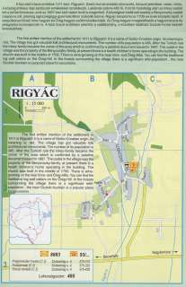
Nyilvános 2461 | 9236 | RIGYÁC | Afalu első írásos említése 1411-ben: Rigyalch. Szerb-horvát eredetű elnevezés, közszói jelentése: veres, vörös. A község értékes népi építészeti emlékekkel rendelkezik. Lakóinak száma 485 fő. A török hódoltság után az Inkey család lett a terület birtokosa, amit az 1697-ben kelt nádori levél is megerősít. A községben található kastély a Benyovszky család tulajdona volt, jelenleg egészségügyi gyermekotthon működik benne. Rigyác temploma az 1700-as évek közepén épült. A településhez közeli Imre-hegyen és Öreg-hegyen szőlőművelés folyik. Az Öreg-hegyen megtalálhatók a hagyományos és jellegzetes boronapincék is. A falut övező erdőkben jelentős a vadállomány, a közelben található Szuloki-forrás kedvelt kirándulóhely. The first written mention of the settlement in 1411 is Rigyalch. It is a name of Serbo-Croatian origin, its meaning is: red. The village has got valuable folk architectural monuments. The number of its population is 485. After the Turkish rule the Inkey-family became the owner of the area which is confirmed by a palatine document issued in 1697. The castle in the village was the property of the Benyovsz\'ky-family, at present there is a health children\'s home operating in the building. The church was built in the middle of 1700. There is wine-growing on the near Imre- and Öreg-Hills. You can find the traditional log wall cellars on the Öreg-Hill. In the forests surrounding the village there is a significant wild-population , the near Szuloki-fountain is a popular place for excursions. The first written mention of the settlement in 1411 is Rigyalch. It is a name of Serbo-Croatian origin, its meaning is: red. The village has got valuable folk architectural monuments. The number of its population is 485. After the Turkish rule the Inkey-family became the owner of the area which is confirmed by a palatine document issued in 1697. The castle in the village was the property of the Benyovszky-family, at present there is a health children\'s home operating in the building. The church was built in the middle of 1700. There is wine-growing on the near Imre- and Öreg-Hills. You can find the traditional log wall cellars on the Öreg-Hill. In the forests surrounding the village there is a significant wild-population , the near Szuloki-fountain is a popular place forexcursions. A részlet a következő kiadványból származik/Die Teile stammen vom volgenden Buch/This text came from the following book: Cím/Titel/Title: Zala megye településeinek atlasza - 257 település részletes térképe/Atlas der Komitat Zala - 257 Detailte Siedlungskarten/Zala county\'s Atlas - 257 settlement maps. Közreműködő/contributor: Lackner László (1943) (fotó) Kiadás/Ausgabe/Publisher: Gyula : HISZI-MAP, 1997 Sorozat/Serie/Series: Indulástól - megérkezésig... ETO: 912(439.121-2) ; 908.439.121 Cutter: Z 19 ISBN: 963-610-025-4 Oldalszám/Seiten/Pages: 323, 81 p. Megjegyzés/Note: Lezárva/Abgeschlossen am/Closed am: 1997. máj. 30. |
